Posted on January 26th, 2022.
The latest version of Carlson’s core office software, including Survey, Civil, Hydrology, Point Cloud, GIS, CADnet, Construction, Trench, Mining, and Natural Regrade, is now available for download!
OVERVIEW
Carlson’s latest desktop software release brings users new features, increased speed, and more efficient workflows. Fully compatible with Windows 11, Carlson 2022 comes with the power of IntelliCAD 10.1, the newly-released update to CAD platform that brings increased speed and new features for Carlson users, and is also compatible with AutoCAD 2017-2022. The 2022 release also delivers powerful new features such as above ground feature extraction, as well as many other time-saving innovations and automated new features, as well as improvements to many major existing elements.
NEW FEATURES
Highlights
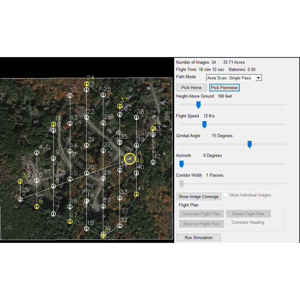
- Drone Mission Planning – New command to create a drone mission plan.
- Carlson PhotoCapture – Added method to download files by file type.
- Collison Check – Added option to draw 3D lines between the crossing pipes along with 3D text for 3D viewing. Added coloring of pipe portions that have conflicts. Added report of minimum horizontal and vertical clearance. Added method to check for collision with a surface model. Added option to color pipe segments with a conflict.
- Utility Network – For pipe labels, added settings to control offset from line and layer for labels. For creating profile at depth, added method to create streamlined profile with min number of profile points and ability to set max depth and min segment length. Added report function to check pipe depths and min/max cover. Added a description field for each utility with option to label in Draw Profile and Draw Sections. For laterals, added location by offset and slope.
- Design Parking Inside Perimeter – Added ability to create islands at ends of parking rows. Added option whether to create spaces around the perimeter and option to add remainder parking space to the corner.
- Design Parking Along Alignment – Added support for alignments with multiple segments, ability to use a polyline or centerline file for the alignment, and support for angled parking. Added functions to create auto treatments and to mirror treatments between left and right sides.
- Automatic TIN (surface model) creation directly from the Draw Field to Finish dialog box
- Bare Earth – Added option to put the ground points into a region instead of creating a new cloud. Added method to create a cloud of the non-ground points.
- Extract Slices – New function to view cross sections of cloud data and create points and polylines.
- Curb Breaklines – New method to create 3D polylines for top and bottom of curb by using edge clusters.
- Create Breaklines By Slope – New function to create 3D polylines at the boundaries of slope zones.
- Color Lines – Added new method for creating polylines that follow color lines in the cloud such as roadway paint stripes and new method to follow color boundaries such as edge between pavement and grass.
- Feature Extraction – Added batch process method to extract multiple features at a time.
- Power Lines – New function to extract overhead wires as polylines.
Source: “https://carlsonsw.com/product/2022“
Comments are closed